‘The Circuit’ appears to be a well-meaning project by the British Heart Foundation (BHF) to register the locations of AEDs. There have been many of these initiatives but like most others this one falls short. I wanted to improve the location data of defibrillators in my area and also have the data integrated into OpenStreetMap so that any citizen could make use of it.
The Problem
Each organisation gathering data on the locations of AEDs ‘owns’ the data and they do not want to share it. This proprietary attitude is (in my opinion) contrary to the objectives of a charity and taxpayer-funded health providers.
Five months ago in December 2022 I contacted ‘The Circuit’ to ask if they would share the locations of the AEDs that they have registered the locations for. The reply came from Edward a “Senior Intelligence Analyst” who advised me that “we already have a website with the defibrillators mapped”. He failed to understand the difference between the data and a visualisation of the data.
I replied several times to Edward but was ignored. One of the messages is shown in appendix 2 below.
In my replies I highlighted to Edward that his map had several AEDs in the wrong locations and I have provided detail in Appendix 1 below for some of those inaccuracies.
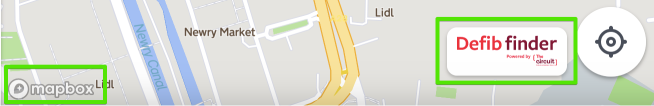
Another disheartening slap-in-the-face comes in the form of a lack of copyright attribution on the defibfinder.uk website. Their website provides a (inaccurate) visual map of the locations of defibrillators but ironically their map is powered by OpenStreetMap. There is a little clickable ‘i’ icon on their website that shows the copyright information and that the data they are using comes from the hard work of volunteers. However, the guidelines from OpenStreetMap point out that this attribution should not be hidden. This is a slap in the face to those of us who volunteer incredible amounts of time creating the map (see Appendix 3). More so since the British Heart Foundation found space to advertise both MapBox and DefibFinder as shown below but hide the contribution of OpenStreetMap volunteers.
The Solution
The silence of the British Heart Foundation indicates:
- They know their AED location data is inaccurate
- They are not interested in the mapping community
- They use our work but do not credit us
I agree that a service is needed to provide the locations of as many defibs as possible but sparking up your own custom solution may not be the best way forward.
I would argue that engaging with local people would allow for more accurate data and ongoing re-validation of the existance of defibs in local communities. OpenStreetMap is already the largest geospatial database worldwide and is freely licensed so that anyone can make use of it for disaster response (the recent earthquakes in Turkey), for social media (Facebook/Bing), for monitoring of health activities (Strava) and for mapping the locations of AEDs. The UK government makes many sources of data available under open licenses so could charities not do the same?
Appendix 1: Examples of incorrect defib locations on defibfinder.uk
The defibfinder.uk website lists 10 devices in Newry, however there are many more available and there are at least 14 listed on OpenStreetMap for Newry. The examples below are for Newry only. There were issues in other towns too but for brevity I am sticking to my home area.
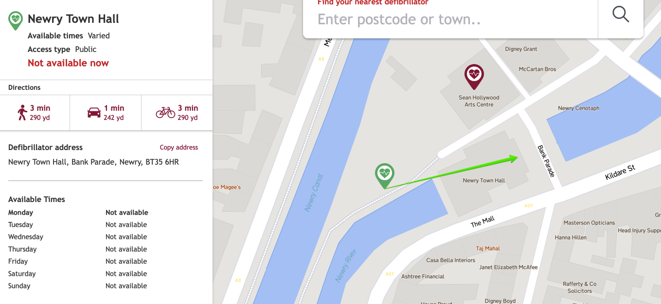
Example 1: Town Hall
In the example below there is an AED listed as being in the Town Hall, but it is in the wrong location and beyond a fence so would be inaccessbile. The correct location is shown by the green arrow.
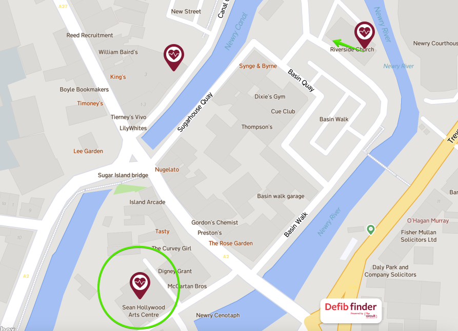
Example 2: Riverside
The AED at the Riverside Church is only 10 metres out of place as indicated by the green arrow. The second defibrillator (circled in green) in the Arts Centre is listed as available during the day but this building has been closed since the covid lockdowns and did not re-open (at the time of writing).
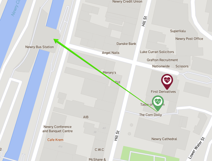
Example 3: Translink
The next two screenshots show AEDs in baffling locations. One was listed as being behind ‘The Corn Dolly’ but I believe this refers to the AED inside Newry Bus Station as indicated by the green arrow.
The next one (below) was listed with an address of ’10 The Mall’. There is no AED at that location and Translink have not used that location as a bus stop for a few decades.

Appendix 2: Email to Senior Intelligence Analyst at British Heart Foundation that received no reply
Hi Edward,
Yes I understand that you have a visual representation of the data at https://www.defibfinder.uk/ but that is not the data itself.
Your website uses the OpenStreetMap (OSM) database of roads, buildings, hospitals and everything else we add. You are using OpenStreetMap as a base layer with your own proprietary layer on top.
What I am asking is if your locations can be actually added as data to the OpenStreetMap database. I understand if your data is proprietary and you do not wish to share it with others but there would be many benefits inc.
– Showing all defibs not just BHF ones
– Analysing locations based on proximity to other facilities such as schools, care homes
– Planning for placement of defibs
– Encouraging volunteers to re-survey to keep records updated
Also since the data on OSM is open/shared you would be able to enhance your own defib map by also showing the defibs that have been added by us volunteers. A quick check of Cookstown shows two that aren’t on your map and a few in Newry too.
I would also point out that OpenStreetMap is a non-profit organisation providing map data and tools globally by the work of many volunteers.
If you have half-an-hour I would be happy to do an online chat and demo how OpenStreetMap works.
Cheers,
jonny
Appendix 3: Contributions to the Map
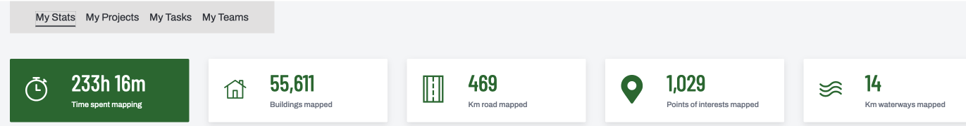
Why is the attribution important? No one likes being taken for granted. I would say that it is important to give credit to those of us who have spent hundreds of hours improving the map so that everyone can benefit. At the time of writing some evidence of my contributions are shown in the screenshots below, with me at 4th most active under the UK stats:
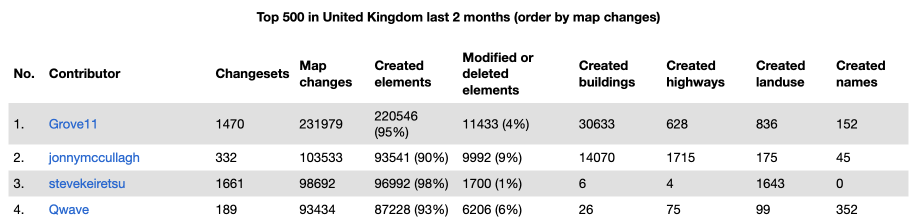
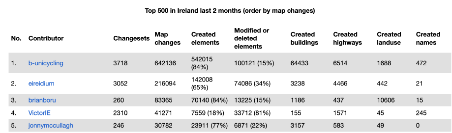
Stats below for contributions via the Task Manager only:
Appendix 4: Attributions
The screenshots used in this post of the defibfinder.uk website show tiles copyright of MapBox and data copyright of OpenStreetMap contributors. Presumably the locations are copyright of DefibFinder but I could not find that information on their website.